Disclaimer: I bought the Sigma Rox 12.0 and returned it within the 14 day cooling-off period. I rode a 200 km commute, tested it for various routing options and rode a 1200 km brevet with it. This post is made based on the initial firmware version that the device was released and shipped with. These issues are hopefully fixed in later versions. But right now. If you are a bikepacker or randonneur and you see the device, turn around, run and don’t look back.
There is already an excellent review by Dcrainmaker, if you want to know more, go check it out. There are many things right in the device, but here are the fundamental flaws:
- It does not show your route
- It does not support routes over 300 km
It doesn’t show your route. Greetings from the engeering orgy. You have to navigate, you can’t just see your route. Not only does routing slow down the device and waste your battery, but you are also likely to be directed off route. There is a red line indicating the correct route, but it is mostly obfuscated by a green line where the device tries to lead you. Brevet organizers and various types of long distance cyclists spend incredible ammount of time and effort to make their route, but Rox 12.0, as of now, doesn’t support showing that route on screen.
It also doesn’t appear to support route waypoints. Good luck spotting those controls. It ”smoothed” out all the controls from our brevet route anyways. Having a navigator and having to check your phone for route is, well, stupid.
It doesn’t support routes over 300 km. You can upload a longer route and view it, but when you start a course it says there is a 300 km limit. This may sound trivial, but I hope next example help you understand the problem. Imagine you are in the middle of a ride and you need to download another route, but it is over 300 km. At that point you can do nothing with it. If you were at home you could always use simple gpx to split your track. But imagine doing it with your cell phone in the middle of Durmitor at night, in rain and dead tired? I had to juggle a route with a memory card to my spare navigator when primary device run out of battery and I had forgot to push one route segment to the spare device.
There is absolutely no reason why Rox 12.0 couldn’t support longer routes, or automatically split them if that is required. There is also no reason why users should adapt to device’s arbitrary maximum distance.
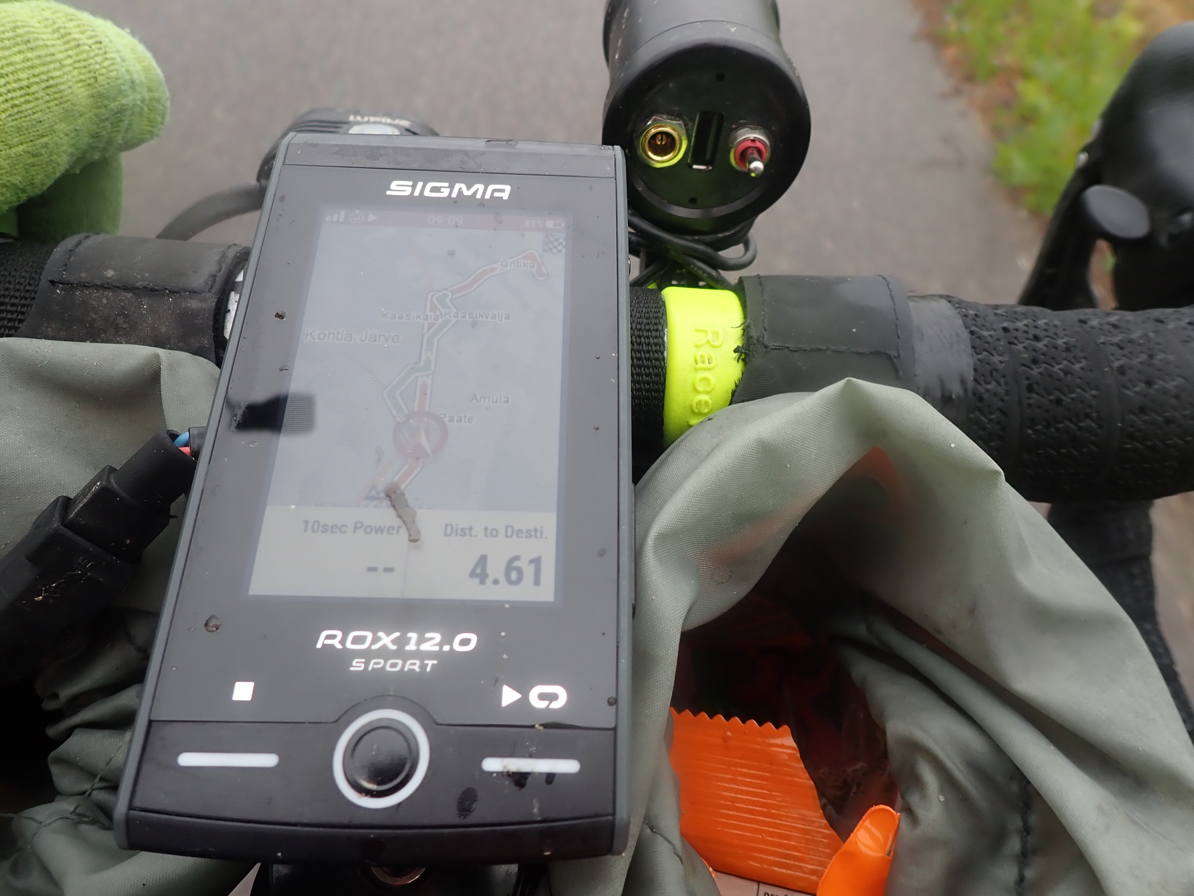
The green line is what Rox guesses I want to ride, ie. result of routing. And Red line is the actual planned route. Depending on quality of your map the green line can be completely off route.
Things to fix
I have returned the device because I didn’t feel like doing product testing for Sigma. In my communication with their customer service there was no realistic timeline of when these fixes would be available.
Anyways, the device is great. It really deserves better software so here is a short list things to fix.
Battery saving mode timeout. Right now the device goes to sleep (continues recording with screen off) by press of power button and wakes up from another press. So you have to remember to put it back to sleep. Also waking it up can be tricky. Any button, or even press of screen, should wake it up.
Per screen map zooms. You can have a map in any of your data screens. Yet if you zoom one map, all maps are zoomed in all screens. Allow different zoom levels on different screens.
Long press of buttons to zoom in/out. By far the most annoying thing to do with navigator mid ride is trying to press those too small +/- buttons. The side buttons now scroll through data screens. With a long press you could zoom in (left?) and out (right?).
Zooming of elevation screen. Well. Simply allow user to set the x and y of the elevetion screen.
Fix gpsies integration. If you have the device you know what I mean. 🙂
There are many other things that need fine tuning, but mostly the device is really good. I didn’t see any hick ups during a 500 km exercise. Battery life was as expected.
And finally. The device isn’t worth much as long as I can’t see my precious route (and maybe my waypoints too). So allow me to stop routing and just display the route. Period.
ps.
Your routing is only as good as your map source, in this case Openstreetmaps. It is not the devices or routing algorithm’s fault. This pedestrian crossing was routed to with ”+major roads, -unpaved, -paths” setting. No navigator can do magic if map source isn’t right. So please go contribute to Openstreetmaps when you find errors.